 Home » Background » Project Description
Project Description
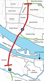
Columbia River Crossing is a bridge, transit and highway improvement project of the Oregon and
Washington transportation departments. The project is charged with reducing congestion and
improving safety problems on a five-mile segment of Interstate 5. The project area stretches from State
Route 500 in Vancouver, Washington, to approximately Columbia Boulevard in Portland, Oregon, including
the Interstate Bridge across the Columbia River.
Purpose and Need
- Improve travel safety and traffic operations on the I- 5 river crossing and nearby interchanges
- Improve connectivity, reliability, travel times and operations of the public transportation systems in
the project area,
- Improve highway freight mobility and address interstate travel and commerce needs in the project area,
and
- Improve the I-5 river crossing’s structural integrity,
- To address the transportation problems on I-5, a mix of public transit and highway solutions are
needed. If we do not move forward with a comprehensive long-term solution now, the problems
will only get worse and more complex.
What Are the Challenges?
- Traffic congestion at the I-5 Bridge currently lasts six hours and is expected to increase to 16
hours by the year 2030.
- On-time freight deliveries are compromised, hampering productivity and efficiency.
- Buses traveling I-5 between Vancouver and Portland get stuck in traffic
and can become less reliable.
- Safety has deteriorated.
- About one crash occurs daily – a rate that is two times higher than similar highways
in Oregon and Washington. Crashes will grow with more congestion.
- Many collisions can be attributed to short on-and off-ramps, inadequate spaces for merging
and weaving, and poor sight distances on and near the I-5 bridge.
- A significant earthquake could damage the I-5 Bridge.
Current Status
The project will analyze two bridge options and two
public transit options in a process to identify
the best combination of options (called “alternatives”) that improve mobility and safety and reduce
congestion in the project area. The result of this study will be a report called a Draft
Environmental Impact Statement, which is required by the National
Environmental Protection Act (NEPA). The CRC project team is working to
define the details of the current alternatives to allow comprehensive study
and analysis during the next phase of the project.
A Brief Overview of the Alternatives
Replacement bridge with bus rapid transit
The Interstate Bridge would be replaced with a new bridge with five or six
lanes in each direction. It will have three “through” lanes and two or three on/off lanes
for both northbound and southbound travel, to allow vehicles to safely enter and exit the highway.
The new bridge also would have a lane for bus rapid transit.
Replacement bridge with light rail
The Interstate Bridge would be replaced with a new bridge with five or six lanes in each direction. It will
have three “through” lanes and two or three on/off lanes for both northbound and southbound travel, to allow vehicles to safely enter
and exit the highway. The new bridge also would have a lane for light rail.
Supplemental bridge with bus rapid transit
The existing Interstate Bridge would be re-striped into four lanes with wider shoulders for northbound
traffic. A new bridge would be built to carry southbound traffic and bus rapid transit.
Supplemental bridge with light rail
The existing Interstate Bridge would be re-striped into four lanes with wider shoulders for
northbound traffic. A new bridge would be built to carry southbound traffic and light rail.
No build
A "no build" alternative is required and serves as a baseline for comparison with other
alternatives. The existing Interstate Bridge and public transit systems
would remain. Only improvements reasonably anticipated for funding and
construction in the Metro and southwest Washington regional transportation
plans would be considered.
Next Steps
Results of the analyses will be available for public discussion in late
2007. A formal public comment period is expected in the spring of 2008 on
the selection of one alternative.
As part of the process to complete the Draft EIS and choose one
alternative, the following issues will be addressed in each of the “build”
alternatives.
- Public transit (route, stations, and park and ride locations)
- Freight improvements for connections and safety
- Efficiencies (such as ramp meters, incident response, ridesharing and telecommuting)
- Bicycle and pedestrian improvements
- Air quality and noise reduction
- Environmental effects
- Cultural and historical resource protection
- High occupancy vehicle lanes
- Tolling, bridge type, appearance, and alignment (upstream or downstream)