| |
|
| |
 |
  |
| |
Why This Project?
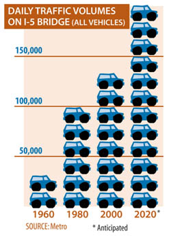
When the I-5 bridge between Vancouver, Washington, and
Portland, Oregon, first opened, 350,000 people lived in the region with fewer
than 20,000 cars and trucks. Now, there are 2 million people and 2 million cars
and trucks.
I-5 is the only continuous north/south interstate highway on
the West Coast, providing a critical commerce link for the United States,
Canada, and Mexico. In the Vancouver/Portland metropolitan region, I-5 is one
of two major highways that connect the two states and the regional economy.
While there is a second major river crossing 6 miles upstream
to the east of the I-5 bridge (the I-205 Glenn Jackson Bridge), this too is
reaching its peak-hour period carrying capacity, leaving no other crossing
options in the metropolitan area.
Simply stated, there isn't enough room on the I-5 bridge to
keep up with demand, and demand will continue to grow. We must find a way to
creatively address the problem. If we don't, traffic congestion for residents,
commuters, businesses, freight, and tourists will only get worse.
|
What Are the Problems?
Who Uses the Bridge?
Project Background
Accomplishments To Date
History of the Bridge
|
|
What Are the Problems?
In looking for solutions, it is critical to clearly understand
the project area and its problems, including the Bridge Influence Area, which
is the 5-mile segment of I-5 from State Route (SR) 500 in Vancouver to
approximately Columbia Boulevard in Portland.
-
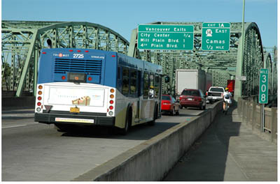
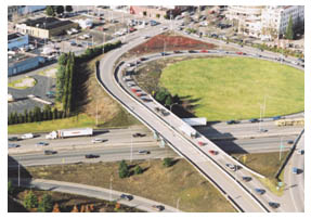
Travel demand exceeds capacity in the
Bridge Influence Area, causing heavy congestion and delay during peak travel
periods for automobile, transit, and freight traffic. This limits mobility
within the region and impedes access to major activity centers.
-
Transit service between
Vancouver and Portland is constrained by the limited capacity in the I-5
corridor and is subject to the same congestion as other vehicles, affecting
transit reliability and operations.
-
The access of truck-hauled freight
to nationally and regionally significant industrial and commercial districts,
as well as connections to marine, rail, and air freight facilities, is impaired
by congestion in the Bridge Influence Area.
-
The bridge crossing area and its approach sections experience
crash rates more than two times higher than statewide averages for
comparable urban highways in Washington and Oregon, largely due to outdated
design. Incident evaluations attribute crashes to congestion, closely
spaced interchanges, short weave and merge sections, vertical grade changes in
the bridge span, and narrow shoulders.
In addition, the configuration of the existing I-5 bridges relative to the
downstream Burlington Northern-Santa Fe rail bridge contributes to hazardous
navigation conditions for commercial and recreational boat traffic.
-
Bicycle and pedestrian facilities
for crossing the Columbia River in the Bridge Influence Area are not designed
to promote non-motorized access and connectivity across the river.
In addition, "low speed vehicles" are not allowed to use the I-5 bridge to
cross the river.
-
The I-5 bridge across the Columbia River
does not meet current seismic standards, leaving them vulnerable
to failure in an earthquake.
-
The current configuration of I-5
within the Bridge Influence Area limits east-west connectivity across the
highway for all users.
-
As the Vancouver/Portland metropolitan region grows, mobility and accessibility
for automobile, freight, and transit will decline unless the disparity between
demand and capacity in the Bridge Influence Area is addressed. The increasing
disparity between demand and capacity will lead to longer
delays, increased accident potential, and diminished quality of life and
economic opportunity.
To read the details of each problem, please
click here or on the sections above.
Back to top
|
|
Who Uses the Bridge?
Typical Travelers
The I-5 bridge carries more than 125,000 automobiles, buses, and freight
vehicles on an average weekday. The Bridge Influence Area serves several broad
travel markets, as explained below:
Through Travel: These users travel
from outside the Vancouver/Portland region to destinations that are also
outside the region-for example, a freight or tourist trip from Seattle,
Washington, to Eugene, Oregon. These users represent about 7 percent of
the total vehicle-trips crossing the river during the peak periods.
Regional Travel: Most of these users
travel between Clark County and the Portland metropolitan area (Multnomah,
Washington, and Clackamas Counties), or vice versa, without stopping in the
Bridge Influence Area. These trips account for about 47 percent of the
total vehicle-trips crossing the river during the peak periods.
Seven percent of the total trips crossing the river originate within the region
and are destined outside of the region, or originate outside of the region and
are destined within the region-for example, a trip from Salem, Oregon, to Clark
County.
Local Travel: Most of these users
travel between the Bridge Influence Area and other locations within the
Vancouver/Portland metropolitan area, or vice versa. For example, a trip
from a southeast Portland neighborhood to downtown Vancouver is considered a
local trip. These trips account for about 32 percent of the vehicle-trips
crossing the I-5 bridge during the peak periods.
Two percent of the total trips crossing the river originate within the region
and are destined to a location within the Bridge Influence Area, or originate
within this area and are destined outside of the region-for example, a trip
from Longview, Washington, to Portland Meadows.
Internal Travel: These users stay
entirely within the Bridge Influence Area -for example, from downtown Vancouver
to Hayden Island. This constitutes about 5 percent of the trips crossing
the I-5 bridge during the peak periods.
Back to top
|
|
Project Background
|
|
The Foundation:
I-5 Transportation and Trade Partnership
In 1998, the Washington and Oregon Departments of
Transportation formed a bi-state partnership to study transportation problems
and possible solutions for the I-5 corridor from the Portland metropolitan area
through southern Clark County. While this study included the Columbia River
Crossing project area, it also encompassed a much broader stretch of the I-5
corridor.
The I-5 Transportation and Trade Partnership Task Force, a
28-member bi-state committee, began its study in January 2000. The Task Force,
which included elected, business, neighborhood, and community representatives,
spent January through June of 2001 working with the public and one another to
determine what improvements should be studied. They reviewed the evaluation
results in the Fall of 2001, and made draft recommendations in January 2002.
The study resulted in a variety of corridor-wide improvement
and traffic management recommendations. The studies showed that the highest
congestion and the most unmet demand occur where I-5 crosses the Columbia
River. Study findings also included a range of improvement and traffic
management recommendations. One key recommendation called for adding more
travel space, or capacity, over the Columbia River with a replacement bridge or
modification of the existing I-5 bridge to ease bottlenecks on local travel and
interstate commerce. Other recommendations included considering high-capacity
transit improvements and a range of financing options. They also stressed the
importance of involving the public, including low-income and minority
populations, in project planning.
These recommendations were subsequently handed over to the
Columbia River Crossing project for more review and implementation. The studies
can be viewed under the project documents page.
The I-5 Partnership newsletters can be viewed
as well.
Back to top
|
|
ODOT's Delta Park to Lombard Development Project
The I-5 Transportation and Trade Partnership recommendations
resulted in the development of the Delta Park project. By locating several
choke points along the I-5 corridor and improving those areas, the larger goal
of interstate improvement is being achieved. The problem in the Delta Park
project area is a southbound, 2-lane section between Delta Park at Victory
Boulevard and the Lombard Interchange. This 2-lane section is located between
3-lane sections and creates a bottleneck for southbound traffic, which causes
congestion on the highway.
The Oregon Department of Transportation (ODOT), is proposing
to:
-
Widen the highway to a 3-lane section southbound from Delta Park, at Victory
Boulevard, to the Lombard Interchange.
-
Widen the Columbia Slough Bridge median and shoulder widths.
-
Provide better access between the I-5 corridor and Columbia Boulevard.
-
Reconstruct sound walls impacted by the project.
This project is in progress and will continue simultaneously
with the Columbia River Crossing project. To learn more about the current
activities of the Delta Park to Lombard project, please visit
ODOT's Web site.
|
|
Back to top
|
|
The Next Step:
Columbia River Crossing Project
The Columbia River Crossing project is the next logical step in
resolving congestion problems in the I-5 corridor. Study and recommendations
will focus on the Bridge Influence Area, a the 5-mile segment of I-5 from State
Route (SR) 500 in Vancouver to Columbia Boulevard in Portland. The project
involves environmental impact studies of the Bridge Influence Area, public
involvement, and multiple review processes, which will result in the selection
of a preferred alternative for addressing the problems. Read more about
How this Project Works. The Columbia
River Crossing Project Team will direct the development and completion
of the project.
Back to top
|
|
Accomplishments To Date
|
|
A substantial amount of groundwork for the Columbia River
Crossing project was completed over the last 7 years. The list below highlights
key milestones and work products.
February 2006:
|
|
The Columbia River Crossing (CRC) Task Force recommends
evaluation criteria that will be used to compare alternatives on how
well they achieve community values.
|
December 2005:
|
|
The Project Sponsors Council concurs with the Task Force's recommendation on
the Problem Definition.
|
November 2005:
|
|
The CRC Task Force creates a final version of the
Problem Definition and, after a series of public open houses and other
public involvement events, recommends it to the Project Sponsors Council. Read
more about these activities on the Survey
Results and Open House pages.
|
|
October 2005:
|
|
The CRC Task Force adopts the Vision
and Values Statement.
|
|
February 2005:
|
|
The CRC Task Force convenes its first meeting.
|
|
September 2004:
|
|
The Washington State Department of Transportation (WSDOT) and the Oregon
Department of Transportation (ODOT) sign a "Memorandum of Understanding" to
jointly pursue the Columbia River Crossing project. They form the Joint
Commission Subcommittee to provide oversight of the project.
|
|
February 2004:
|
|
WSDOT and ODOT begin work to further develop recommended project concepts from
the I-5 Transportation and Trade Partnership and consider financing options and
issues.
|
|
April 2003:
|
|
Regional Economic Effects on the I-5 Corridor Columbia River Crossing
Transportation Choke Points Report (4.5MB PDF) is published by the I-5
Transportation and Trade Partnership.
|
|
February 2003:
|
|
The Bi-State
I-5 Rail Capacity Study (1.1MB PDF) is completed.
|
|
January 2003:
|
|
ODOT begins work on the environmental assessment for widening
I-5 from Delta Park to Lombard Street.
|
|
November 2002:
|
|
WSDOT completes an I-5 widening project from
Burnt Bridge Creek in Vancouver to NE 78th Street in Hazel Dell.
|
|
June 2002:
|
|
The I-5 Transportation and Trade Partnership Task Force adopts the
Final Strategic Plan Recommendations (5.8MB PDF) for I-5 corridor
improvements.
|
|
March 2000:
|
|
A 100-member
Community Forum is formed to provide guidance on development of a
strategic corridor plan. The forum is composed of citizens representing
neighborhood, business, environmental, and other interests in the corridor.
|
|
January 2000:
|
|
I-5 Transportation and Trade Partnership Task Force releases the
Portland/Vancouver I-5 Trade Corridor Freight Feasibility and Needs Assessment
Study Final Report (4.8MB PDF).
|
|
December 1999:
|
|
WSDOT and ODOT begin the bi-state transportation and trade corridor study.
Governors Gary Locke and John Kitzhaber appoint a 28-member Bi-State
Task Force of community, business, and elected representatives to help
WSDOT and ODOT develop an I-5 regional strategic plan.
|
Back to top
|
|
History of the Bridge
|
|
Shift from Ferry to Bridge Travel: The 1917
Bridge
On June 1, 1905, the first world's fair to be held in the
Pacific Northwest-the Lewis and Clark Centennial and American Pacific
Exposition and Oriental Fair-opened in Portland, Oregon. Exposition organizers'
goal was to promote Portland as the commercial hub of the Pacific Northwest and
the centennial of Lewis and Clark's nation-building journey across the
continent in 1805 provided the perfect theme.
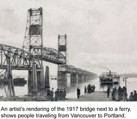
Even though the fair was a promotional boon to the
Vancouver/Portland area, it caused a massive traffic jam at the Columbia River
steam ferry, which was one of the few passageways from Vancouver, Washington,
to Portland. This sparked widespread demand for a bridge between the two
states. In 1914, with a great deal of bi-state local support, the Washington
and Oregon state legislatures approved the sale of bonds to fund such a bridge
and construction began in 1915. The new bridge opened on February 14, 1917,
amid much fanfare.
Back in 1917, it cost travelers a 5 cent toll to cross the
Interstate Bridge. There were only two lanes for traffic - one in each
direction - and a streetcar shared the roadway with cars. Previously, the only
way to cross the river between Vancouver and Portland was by ferry. Because the
bridge was heavily used, the original $1,683,000 bond was paid off within 12
years! Originally built and owned by Clark and Multnomah Counties, the bridge
was taken over by the two states in 1929, tolls were removed, and the remaining
bond debt paid off with tax dollars.
|
|
For more information about the Lewis and Clark Exposition,
visit the Oregon Historical
Society's Web site.
|
|
The Era of the Automobile: The 1958 Bridge
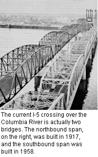
The end of the Vancouver and Portland streetcar service in the
1940s and increased travel on the bridge prompted Washington and Oregon to look
into increasing the capacity of the bridge. Traffic rates had skyrocketed and
it was time to look for solutions. In 1936, for example, daily traffic volumes
on the bridge were only 13,100; by 1950 that number had jumped to 30,747. A
dramatic increase in marine traffic also required more bridge lifts, which made
traffic problem even worse.
Between 1944 and 1951, Washington and Oregon joined together to
study the options for constructing a second bridge. Alternate sites for a
second bridge were investigated, but it was eventually determined that building
a new bridge immediately adjacent to the existing bridge was the most feasible
solution. The cost of the entire project-including design, engineering,
right-of-way acquisition, building the nearby Oregon Slough Bridge, remodeling
the 1917 bridge, and installing new lighting, landscaping, and toll plaza
equipment-totaled $14.5 million.
In 1953, the Washington and Oregon state legislatures
authorized the sale of bonds to design and build a second bridge. Construction
was completed in 1958 and a ribbon-cutting ceremony occurred on July 1, 1958.
Tollbooths were installed in 1960 after remodeling work on the 1917 span had
been completed. To pay off the construction bond, tolls of 20 cents for cars,
40 cents for light trucks, and 60 cents for heavy trucks and buses were
collected until 1966.
To serve the growing traffic on the new I-5 highway, a second
parallel drawbridge opened in 1958 and, after an additional 2-year
refurbishment of the old bridge, tolls were reinstated in 1960 to pay off the
new bonds. The refurbishment included raising the center span to reduce the
frequency of lift-span openings. The bridge debt was retired in 1967 and the
tolls were removed.
For more information about the bridges, view the
links page and choose from the "More information" options at the bottom
of the page.
Back to top
|
|
|