In looking for solutions, it is critical to clearly understand the project area and its problems, including the Bridge Influence Area, which is the 5-mile segment of I-5 from State Route (SR) 500 in Vancouver to approximately Columbia Boulevard in Portland. The following problems were outlined in the Problem Definition, which was recommended by the Task Force in November 2005. The Project Sponsors Council concurred with this recommendation in December 2005.
| Current Problems
|
Details/Background
|
| 1. Travel demand exceeds capacity in the Bridge Influence Area, causing heavy congestion and delay during peak travel periods for automobile, transit, and freight traffic. This limits mobility within the region and impedes access to major activity centers. |
Heavy traffic congestion has resulted from growth in regional population and employment and in interstate commerce over the last two decades. The existing I-5 bridge crossing provides 3 lanes of capacity in each direction, with a directional capacity of about 5,500 vehicles per hour. Travel demand currently exceeds that capacity during peak periods. As a result, stop-and-go traffic conditions last 2 to 5 hours in the mornings and afternoons. These conditions are aggravated by vehicle merges, traffic accidents, and vehicle breakdowns. Due to excess travel demand in the Bridge Influence Area, many travelers take longer, alternative routes such as I-205, or circulate on local streets to less direct I-5 interchanges. In addition, spillover traffic from I-5 onto parallel arterial roadways increases local congestion.
Although the lift span is used only in off-peak hours, it affects travel reliability and creates extensive traffic delays. The span is opened 20 to 30 times a month, with the greatest number of lifts occurring during the winter when water levels are at their highest. Each lift takes approximately 10 minutes, creating traffic delays for up to an hour. During peak periods when the lifts are not allowed, river traffic must maneuver a tight "S" curve route through the rail bridge opening and the highest fixed span of the I-5 crossing, creating hazardous navigation conditions.
Back to top
|
| 2. Transit service between Vancouver and Portland is constrained by the limited capacity in the I-5 corridor and is subject to the same congestion as other vehicles, affecting transit reliability and operations. |
The I-5 bridge is a critical bi-state transit link for transit patrons traveling between Vancouver and Portland. Bi-state transit service includes local fixed-route bus service between downtown Vancouver and downtown Portland (using the I-5 bridge), commuter-oriented peak period express routes from Clark County park-and-rides and transit centers to downtown Portland on both I-5 and I-205, and I-205 shuttle service between Fisher's Landing Transit Center and the Parkrose Transit Center.
Current congestion in the Bridge Influence Area has an adverse impact on transit travel speed and service reliability. Between 1998 and 2005, local bus travel times between the Vancouver Transit Center and Hayden Island increased 50 percent during the peak period. Local buses crossing the I-5 bridge in the southbound direction currently take more than three times longer during parts of the morning peak period compared to off-peak periods. On average, local bus travel times are between 10 percent and 60 percent longer when traveling in the peak period direction.
Commuter buses also experience congestion and incident-related delays. Commuter buses traveling southbound during the morning peak period have travel times between 45 percent and 115 percent longer than commuter buses traveling during off-peak periods. Commuter buses traveling northbound during the afternoon peak period have the advantage of using the northbound high occupancy vehicle (HOV) lane, however, these buses still experience travel times between 35 percent and 60 percent longer than commuter buses traveling during the off-peak periods.
Back to top
|
| 3. The access of truck-hauled freight to the nationally and regionally significant industrial and commercial districts, as well as connections to marine, rail, and air freight facilities, is impaired by congestion in the Bridge Influence Area. |
I-5 is the primary supply-chain for goods moving into and out of the Vancouver/Portland region and the Pacific Northwest. Access to nationally and regionally significant industrial and commercial districts, including the Ports of Vancouver and Portland and connections to marine, rail, and air freight facilities, are adversely affected by congestion in the Bridge Influence Area. Congestion is increasingly spreading into the off-peak periods (including weekends) used by freight carriers. Declining freight carrier access slows delivery times and increases shipping costs, diminishing the attractiveness of I-5 and the uses served by I-5, and negatively affecting the region's economy.
Recent forecasts indicate that truck traffic in the region will double, and the logistics requirements for freight delivery time will become increasingly "just-in-time" - placing even more pressure on travel time reliability.
Back to top
|
4. The I-5 bridge crossing area and its approach sections experience crash rates more than two times higher than statewide averages for comparable urban highways in Washington and Oregon, largely due to outdated design. Incident evaluations attribute crashes to congestion, closely spaced interchanges, short weave and merge sections, vertical grade changes in the bridge span, and narrow shoulders.
In addition, the configuration of the existing I-5 bridges relative to the downstream Burlington Northern-Santa Fe rail bridge contributes to hazardous navigation conditions for commercial and recreational boat traffic.
|
More than 300 reported crashes occur annually in the Bridge Influence Area, with many involving large tractor-trailer trucks. Crashes have resulted in substantial property damage and injury; some have resulted in fatalities. The causes are:
Close Interchange Spacing
The 5-mile Bridge Influence Area contains eight closely spaced interchanges. These interchanges provide access to several east-west highways and arterial roadways that serve a mix of interstate, regional, and local trip purposes. The average distance between the interchanges is 1/2 mile, as compared with a recommended minimum spacing of 1 mile between interchanges located in urban areas.
Short Weave and Merge Sections
Short weave sections for vehicles entering and exiting the highway generate backups and delay due to difficulty in maneuvering, especially for large trucks. The proportion of trucks is high because this segment provides arterial street access to both ports.
Outdated designs for entrance and exit ramps cause backups onto the mainline at exit ramps. Most of the entrance ramps do not provide enough space for vehicles to merge safely with through traffic.
Vertical Grade Changes
Vertical grade changes in the bridge span over the Columbia River create sight distance limitations that reduce speeds and create potential hazards to motorists.
Narrow Highway Shoulder Width
Several segments of the Bridge Influence Area, including the I-5 bridge, have narrow inside and outside shoulders in both travel directions. In several locations, shoulders are as little as 1 foot wide (10- to 12-foot wide shoulders are standard).
The lack of shoulders positions many motorists undesirably close to the physical barriers that border I-5. Many drivers respond with caution by slowing down to increase separation from vehicles ahead and behind. Increased vehicle spacing reduces vehicle throughput and contributes to freeway congestion.
In addition, the lack of safe areas for incident response, disabled vehicle pullout, and driver recovery also impairs the ability to manage highway operations and recover from events that interrupt traffic flow.
Hazards for River Navigation
The I-5 crossing's lift span cannot be raised during peak traffic periods. This requires river traffic heading downstream on the Columbia River to navigate under the bridge's high fixed spans near the middle of the river, then quickly turn to line up with the narrow opening of the rail bridge on the north side of the river. This maneuver is especially difficult during high river levels and could result in a collision between a vessel and one of the bridges.
Back to top
|
5. Bicycle and pedestrian facilities for crossing the Columbia River in the Bridge Influence Area are not designed to promote non-motorized access and connectivity across the river.
In addition, "low speed vehicles" are not allowed to use the I-5 bridge to cross the river. |
The width of the bicycle/pedestrian facility on the I-5 bridge is substandard (6 to 8 feet) and located extremely close to traffic. Separated multi-use paths should be at least 10 feet wide.
Bicycle and pedestrian connections between North Marine Drive, Hayden Island, and Vancouver require out-of-direction travel. For example, no connection exists for pedestrians or bicyclists wanting to stay on the west side of the bridge between Hayden Island and North Marine Drive. In addition, many of the Bridge Influence Area’s features are not in compliance with Americans with Disabilities Act design guidelines.
"Low speed vehicles" can be propelled via various means, including through the use of different fuels or electric power. These vehicles must have seatbelts, windshields, turn signals, headlights, brake lights, and other safety equipment. According to the National Highway Traffic Safety Administration, "low speed vehicles" are capable of speeds of up to 25 miles per hour and can be operated on streets with posted speed limits of 35 miles per hour or less. Since I-5 is posted for freeway speeds and since the bridge's multi-use pathway is narrow and permits only non-motorized vehicles, "low speed vehicles" are not allowed to use the I-5 bridge to cross the river.
Back to top
|
6. The I-5 bridges across the Columbia River do not meet current seismic standards, leaving them vulnerable to failure in an earthquake.
|
Previous studies concluded that the existing structures could not be upgraded to fully meet seismic design standards without full bridge reconstruction.
Back to top
|
7. The current configuration of I-5 within the Bridge Influence Area limits east-west connectivity across the highway for all users.
|
There are a limited number of overcrossings and undercrossings of I-5, particularly across I-5's approaches to the Columbia River bridge crossing, i.e., between downtown Vancouver to the west of I-5 and the numerous land uses to the east of I-5 and between Jantzen Beach and Hayden Island. Users wishing to travel across I-5 often must take circuitous routes.
Back to top
|
| Future Problems
|
Details/Background
|
8. As the Vancouver/Portland metropolitan region grows, mobility and accessibility for automobile, freight, and transit will decline unless the disparity between demand and capacity in the Bridge Influence Area is addressed. The increasing disparity between demand and capacity will lead to longer delays, increased accident rates, and diminished quality of life and economic opportunity.
|
Regional Growth
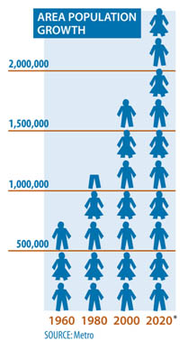
Consistent with regionally adopted comprehensive plans, the region’s growth forecasts indicate that population, employment, and commercial trade will continue to grow, increasing regional travel demand.
Between 2005 and 2030, the population of the four-county Vancouver/Portland region is projected to increase by 44 percent, from 1.96 million to 2.82 million.
Regional trade is expected to almost double over the next 25 years to over 520 million tons. While currently 64 percent of the region's freight tonnage is hauled by truck, by 2030 it is projected that 73 percent will be carried by truck, many including container loads.
Increased Travel Demand
Daily traffic demand over the I-5 bridge is expected to increase by more than 40 percent in 20 years, from 125,000 vehicles in 2000 to 180,000 vehicles in 2020 (traffic is expected to further increase beyond 2020; new travel demand modeling is currently being conducted to predict 2030 levels). The projected increase in use of the bridge is constrained by the lack of capacity to accommodate more vehicles, resulting in an expansion of the peak period to accommodate the projected traffic increase. There will also be a potentially large and underserved transit market for trips between key regional locations traveling or connecting through the Bridge Influence Area.
Deteriorating Traffic Conditions
Unless improvements are made, traffic conditions in the Bridge Influence Area are predicted to worsen over the next 20 years:
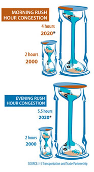
Traffic congestion and delay will increase, with stop-and-go conditions occurring in both directions for 10 to 12 hours on weekdays. Increased delays on weekends will also result.
The current off-peak periods, which are generally uncongested and favored by freight carriers, will blend into adjacent peak period congestion, increasing freight delay throughout much of the day.
Vehicle-hours of delay during the evening commute period will increase nearly 80 percent, from 18,000 hours to 32,000 hours each day. Vehicle hours of delay on truck routes will increase by more than 90 percent: from 13,400 hours to 25,800 hours each day.
Average travel times for buses traveling in general purpose lanes on I-5 between downtown Vancouver and downtown Portland are expected to almost double: from 27 minutes in 2000 to 55 minutes in 2020.
With an extension in the duration of congestion, there may be pressure to increase the bridge lift closure periods, further hampering river navigation and increasing the likelihood of accidents between vessels and the bridge.
As traffic demands increase, accident levels will likely rise within the Bridge Influence Area.
Diminished Mobility and Accessibility
Slower highway speeds will reduce access to jobs, shopping, and recreational uses.
Regional truck freight is projected to increase by about 130 percent over the next 25 years; however, increasing delays between I-5 and freight centers will adversely affect freight distribution and access to ports and terminals, thereby shrinking market areas served by the Vancouver/Portland region.
The current Regional Transportation Council Metropolitan Transportation Plan and the Metro Regional Transportation Plan recognize the need for additional capacity to improve the flow of people and freight in the Bridge Influence Area. Both plans include the I-5 Transportation and Trade Partnership Strategic Plan recommendations to increase mobility and accessibility in the Bridge Influence Area.
Back to top
|
|